

Why this route?
After a day on a packed Bright Angel trail, we were looking for something calmer and Hermit’s Rest seemed like the right place to visit. This trail is way less crowded, allowing us to admire the canyon in solitude (we met five people during this hike!). We also found this route rather diverse with changing views and different terrains.
How to get there?
When visiting in March – November: the Hermit road is closed for private vehicles so you need to take a shuttle. The shuttle stop is at the Hermit Road Transfer Station (Grand Canyon village) which connects the blue and red route busses.
When visiting in December – February: the shuttle bus service is not available and the Hermit road is open for private vehicles, so you can access the trail by car only. The road might close if weather conditions are bad but then you should probably not hike there either 
So how was it?
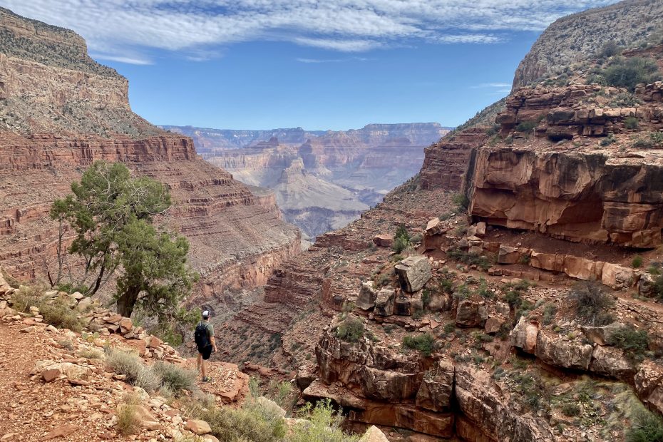
I’d say the beginning of the trail was the hardest part. The trail is definitely less maintained compared with the Bright Angel trail – the rocky, steep and uneven surface kept us busy and focused for a while. Gradually the trail leveled and we walked among sparse trees and bushes.
Midway through our descent, we came across a stunning viewpoint with layers and layers of canyon showing up. That’s what I liked about this trail the most – it’s so diverse! Within a short hike we saw different faces of the Canyon.
We actually thought that the Santa Maria Spring was further than expected so when we reached a rest house, it took a few minutes of checking the location to realize we reached the goal of today 😄
I still walked a bit further and was intrigued by the ridges, hoping to see a tad more if I just walk a bit further… 
| Cookie | Duration | Description |
|---|---|---|
| cookielawinfo-checbox-analytics | 11 months | This cookie is set by GDPR Cookie Consent plugin. The cookie is used to store the user consent for the cookies in the category "Analytics". |
| cookielawinfo-checbox-functional | 11 months | The cookie is set by GDPR cookie consent to record the user consent for the cookies in the category "Functional". |
| cookielawinfo-checbox-others | 11 months | This cookie is set by GDPR Cookie Consent plugin. The cookie is used to store the user consent for the cookies in the category "Other. |
| cookielawinfo-checkbox-necessary | 11 months | This cookie is set by GDPR Cookie Consent plugin. The cookies is used to store the user consent for the cookies in the category "Necessary". |
| cookielawinfo-checkbox-performance | 11 months | This cookie is set by GDPR Cookie Consent plugin. The cookie is used to store the user consent for the cookies in the category "Performance". |
| viewed_cookie_policy | 11 months | The cookie is set by the GDPR Cookie Consent plugin and is used to store whether or not user has consented to the use of cookies. It does not store any personal data. |
I hiked this trail in 1994. It was unmarked due to rains washout which were not replaced and completely unmaintained at that time.. we went down to the Colorado river in one day camped there then attempted to go back up to the rim next day. It was strenuous and there was no water, almost lost it half way back up which required a miraculous rescue back up to the Santa Maria Spring. I hope it is now safer than back then and better marked for the safety of hikers. It is VERY BEAUTIFUL and very dangerous too. By the way, the park rangers are wonderful and awesome people! Wish I could remember the names of those who helped us back then… if you are still around many BLESSINGS to you♥️🦅…
Oh dear, that sounds intense! I’m glad it all turned out fine and now you have a story for a lifetime. I wouldn’t say the trail is well marked, but I guess it’s because I’m used to Europe, where trails have markings every 500m 😄 However, it was easy to navigate until the springs as there was pretty much no other way (except for one junction). The trail is quite well maintained but definitely less than Bright Angel. I’m sure the further down you go, the more wild it gets simply because not many people go that way. I wish I had a chance to go all the way to the Colorado river, maybe next time 😉